The AECO Guide to 3D Gaussian Splatting: Faster, Photorealistic Reality Capture
Reality capture across design, engineering, construction, and operations is undergoing a major shift away from slow neural rendering and complex photogrammetry meshes toward 3D Gaussian Splatting (3DGS). By converting standard drone or smartphone video into real-time, navigable 3D environments, 3DGS bridges the gap between raw visual site capture and technical CAD/BIM workflows.
What is Gaussian Splatting and Where Did It Originate? First introduced at SIGGRAPH 2023 by Bernhard Kerbl and researchers at INRIA, Gaussian Splatting was engineered to overcome the severe processing bottlenecks of Neural Radiance Fields (NeRFs). Instead of evaluating heavy neural networks or connecting triangles into rigid surface meshes, 3DGS reconstructs scenes using millions of semi-transparent, overlapping 3D ellipsoids (Gaussians).
Each splat contains spatial position, 3D covariance (size and orientation), color (via spherical harmonics), and opacity. By leveraging tile-based GPU rasterization, computers can render high-resolution reflections, shadows, transparent surfaces, and complex geometries on standard hardware.
While processing speed is steadily improving, generating these models still demands more computation than traditional RGB point-cloud or 360-degree panoramic pipelines. However, the resulting visual realism is significantly higher.
Key Comparison: Splats vs. NeRFs vs. Photogrammetry
| Feature | 3D Gaussian Splatting | NeRFs (Neural Radiance Fields) | Photogrammetry Meshes |
|---|---|---|---|
| Visual Detail | High (reflections, glass, foliage, smoke) | High | Fails on glass, shine, thin features |
| Hardware Required | Standard phones/cameras/drones | High-end workstation GPUs | Laser scanners / standard cameras |
| CAD/BIM Usability | Visual context overlay & BIM integration | Visual context only | Native geometry mesh / point cloud |
Applications Across the Building Lifecycle
1. Architecture & Design Context Architects can capture adjacent site environments and drop digital design assets straight into photorealistic visual surroundings. Rendering engine integrations like Chaos V-Ray 7 and Chaos Vantage 3 allow designers to evaluate architectural designs within real site lighting without time-consuming offline light-baking. Another benefit of Gaussians is their use of spherical harmonics, enabling realistic representations of how light interacts with a scene from different camera angles.
2. BIM Overlay & MEP Engineering 3DGS serves as a rich visual layer over intelligent BIM objects. Viewers like Autodesk Platform Services (APS) and Bentley iTwin allow project teams to slice section planes simultaneously through both the CAD design and the splat capture, validating overhead MEP runs before walls close in.
3. Surveying & High-Accuracy Hardware Fusion
While 3DGS excels at visual fidelity, precise engineering workflows require tight dimensional control. Reality capture teams increasingly combine 3DGS with terrestrial scanners like the FARO Focus series or mobile SLAM capture with FARO Orbis. In these hybrid pipelines, millimeter-accurate LiDAR point clouds establish the exact geometric framework, while 3DGS generates the photorealistic visual layer—eliminating geometric drift without sacrificing render quality.
4. Construction Progress Tracking & 4D Timelines Field workers recording routine video walks can generate temporal 4D site models. Web platforms like Gauzilla Pro and Splat Labs enable remote teams, owners, and contractors to scrub through site progress over time, verify payment milestones, and resolve disputes using immutable spatial records.
5. Operations, Maintenance & Immersive Walkthroughs Facility operators retain precise visual as-built captures to inspect hidden utility infrastructure long after construction ends. Centralized digital reality ecosystems—such as FARO Sphere XG, ScanOps by Luminous XR, and browser-based splat viewers—allow offsite stakeholders to conduct photorealistic virtual walkthroughs across desktop, mobile, or VR headsets without physical travel.
Integrations and Tooling Ecosystem
Mobile Field Capture: Polycam, Luma AI, Scaniverse, KIRI Engine, FARO Orbis Premium (360 Flash images).
Aerial & Infrastructure Mapping: DJI Terra, Pix4D, Esri ArcGIS Reality Studio.
Desktop Processing: PostShot (desktop local processing), Lichtfeld Studio, 360 Gaussian Pro, and Splatica, Chaos Vantage 3 / V-Ray 7.
BIM & Scanning Processing: SHARE PointClouds Studio, Autodesk Revit (with plugins), FARO SCENE.
Web Viewers & Platforms: Gauzilla Pro, Splat Labs, ScanOps by Luminous XR, SuperSplat (free browser editor to crop and compress splat files by up to 90%), FARO Sphere XG (PC/3D viewing platform).
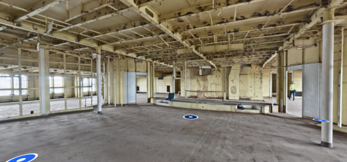
The image below is a 360-degree image that is being used to generate a 3D Gaussian Splatting model. Data was captured using a FARO Blink Imaging Laser Scanner during Phase 2 Reality Capture on the SS United States in Mobile, Alabama. Point3D was part of a team testing mobile scanning solutions and emerging capture technologies in a real-world shipboard environment.
Tags: Scan-to-BIM, Sphere® XG
Categorized in: Articles
This post was written by Soniel San Pedro