Evolution of 3D Handheld Mapping Systems
Over the past decade, the world of laser scanning has evolved from the commonplace use of tripod-based systems to the newer technology of 3D mobile mapping. Once a costly and cumbersome technology employed in mining and construction applications, laser scanning has become one of the most optimized tools in various commercial and industrial development applications; mining and underground excavation, sub-sea, urban mapping, forestry, and facilities management. Improvements in automation, increased speed, reduced size, and lower cost have extended use into many unique projects where time and money are critical.
Mobile mapping systems are now used throughout the complete project life cycle and by all disciplines involved in the design, construction, and maintenance. On a brownfield project, the designer is the first to use scan data to verify existing documentation and develop the initial design concept. Next, the project manager will plan site changes with the benefit of the point cloud model. Then engineers overlay scans over the various mechanical, electrical, and piping design models looking for potential clashes. Finally, with a 3D composite model created, all parties can visualize the completed project. The contractor then uses the data from drawings and scans to verify timelines, manage employee requirements, and calculate accurate material costs; the end-user or client will use all this documentation to maintain the facility and equipment, train employees, and plan future projects.

Initially developed for robots and autonomous appliances, mobile mapping systems differ from traditional terrestrial laser scanners (TLS) by relying on modern Simultaneous Localization and Mapping (SLAM) algorithms rather than targeting and survey control. This SLAM technology essentially performs a traverse scan as you move and automates a significant amount of the mapping workflow. In addition, mobile mapping has matured substantially since its introduction to the market. Newer systems use algorithms that reduce tracing errors and drift automatically; they also offer a reliable process for correcting errors manually, thus allowing you to maximize the accuracy of your final point cloud.
Terrestrial laser scanners (TLS) provide a highly accurate scan, but some are bulky, and traditional survey-based targeting is time-consuming. SLAM-based mobile mapping systems allow the user to walk through an environment, building a map as they go. In removing laborious setups, survey times are slashed, and data acquisition up to ten times faster. In addition, mobile scanners can be carried by hand or in backpacks, mounted to vehicles or drones, and even connected to poles, thus allowing access to challenging and confined spaces not previously accessible.
Mobile technology varies between manufacturers; they use different sensors, cameras and their SLAM algorithms are proprietary and vary in data quality. Although leading manufacturers such as GeoSLAM, DOT Product, and Mantis Vision are fully integrated with most workflow applications, smaller, newer developers may be limited to specific applications. Therefore, the selection of the correct mobile scanning system will depend on the objectives of your project.
This article will review the many possibilities of our three most popular 3D handheld scanner manufacturers.
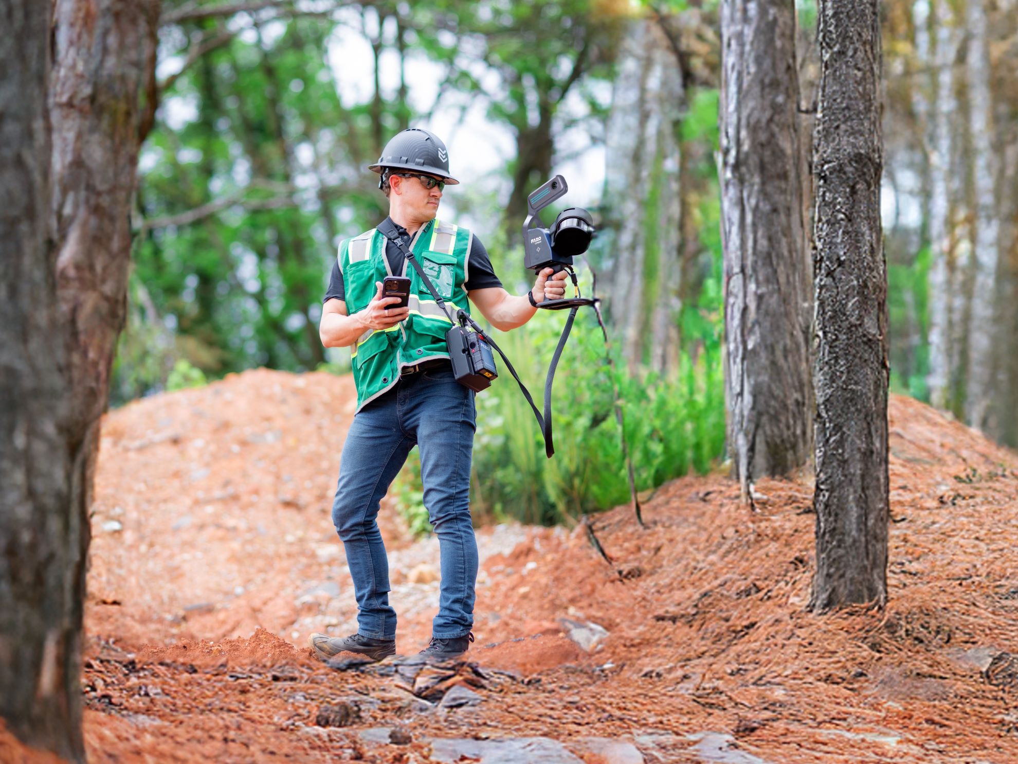
GeoSLAM is a fast scanning, go-anywhere mapping system incorporating user-friendly software. Ideal for large-scale, rapid capture projects and challenging environments such as caves, mines, forests, and open fields. It creates real-time site surveys of residential, commercial, and industrial facilities—ideal for comprehensive documentation of existing structures to be refurbished, remodeled, or extended. The GeoSLAM scanners are a complete unit that transmits data directly to point cloud formats without user input.

The new GeoSLAM 3D process automation solution, Connect, provides weekly progress monitoring and easy data distribution to all parties providing clear, open communication throughout the project life cycle. In addition, continuous improvement and refinement have made the GeoSLAM algorithm equally efficient outdoors as it is indoors.
| ZEB Go | ZEB Revo RT | ZEB Horizon | |
|---|---|---|---|
| Rating | IP64 | IP51 | IP54 |
| Range | 30m | 30m | 100m |
| Accuracy | 1-2cm* | 1-2cm* | 1-2cm* |
| Best Usage | Indoor | Indoor | Indoor and Outdoor |
| ACCURACY REPORT |
The ZEB Go and ZEB Revo RT are medium-range data capture systems designed for rapidly mapping building interiors. These scanners can quickly map an entire floor and convert it to a 2d plan or 3D model. The ZEB Horizon combines the same rapid capture with long-range allowing surveyors to map large areas like a school campus. Additionally, the Horizon mounts easily to a vehicle enabling a single surveyor to capture an entire street setting.
DOTProduct produces lightweight all-in-one handheld scanner/tablet units. Their DPI scanners are excellent for medium-range and short-range applications such as mapping mechanical service areas. The largest site capturable in one scan is approximately 750 sq ft; however, activating the larger screen capture functionality may increase that size to 1000 sq ft. SR (short-range) models are particularly adept at scanning equipment, objects, and very tight spaces.

DOTProduct scanners, operating Dot3D scanning software, capture interior and exterior spaces, delivering accurate high-resolution color scan data in minutes. Furthermore, point cloud data can be reviewed and edited immediately on the tablet and exported directly to industry-standard color point cloud formats. Dot3D can be installed on many tablets or phones and is compatible with a growing list of powerful 3D cameras, allowing for high resolution/high accuracy data capture even in daylight. Additional accessories include a light kit for dark spaces and an extension kit for hard-to-reach areas.
| DPI-10 | DPI-10SR | DPI-X | DPI-XSR | |
|---|---|---|---|---|
| Range | 2-12ft | 1-6ft | 2-12ft | 1-6ft |
| Accuracy | 2-5mm | 2-4mm | 2-5mm | 2-4mm |
| Best Usage | Long-range | Short-range | Long-range | Short-range |
| Intel RealSense D415 Camera | Intel RealSense D455 Camera | Intel RealSense L515 Camera | |
|---|---|---|---|
| Ideal Range | .5m to 3m (1.6ft to 9.8ft) | 0.6m to 6m (1.9ft to 19.6ft) | 0.25m to 9m (0.8ft to 25.5ft) |
| Depth Resolution | 1280px x 720px | 1280px x 720px | 1024px x 768px |
| Frame Rate | @ 90fps | @ 90fps | @ 30fs |
With cross-platform and cross-sensor compatibility, DOTProduct software integrates with most market workflow programs such as AutoDesk, AVEVA, Bentley, Bloom Cloud Engine, ClearEdge3D, WorldViz, Z+F, and many others. Compatible with a variety of devices, it is the most budget flexible mobile scanning system.
Mantis Vision scanners make fast and highly accurate 3D color scene capture accessible to anyone. Their F6 industrial 3D scanner turns mechanical equipment, piping spools and, small workspaces into high-resolution 3D point clouds and mesh models in real-time. Easy to use with no need for scene preparation or targets, Mantis Vision scanners are particularly effective in small areas and hard-to-reach places. In addition, challenging lighting conditions can be captured with a bright LED light attachment. Their advanced accuracy and ability to operate indoors and outdoors make Mantis Vision scanners indispensable for highly complex projects such as mapping mechanical spaces, reverse engineering, forensics, architectural feature documentation, and modeling for AR/VRI.

The F6 models are a two-component system consisting of a handheld scanner and a separate tablet running the Echo software. The technician operates the scanner like a wand while seeing the data developing on the screen. These lightweight scanners have a built-in camera to colorize point clouds and produce photorealistic textured mesh models. The F6 units operate using Mantis Vision’s free Advanced Echo software, compatible with CAD or Solidworks platforms. In addition, Mantis Vision’s proprietary critical feature density makes it ideal for scanning intricate equipment and systems like an oil tanker control system.
| F6 Smart | F6 Short Range | |
|---|---|---|
| Range | 0.5-4m | 0.2-0.75m |
| Accuracy | 500 micron | 100 micron |
| Depth Resolution | 1mm | 0.4mm |
The mobile laser scanning industry is in a progressive change. As mobile mapping systems continue to become more accurate and sophisticated, able to accommodate any challenges introduced, project applications continue to increase. Users have substantial control over the quality of the final deliverable, and as a result, our ability to accurately scan any surrounding environment has grown dramatically.
Investing in a 3D mobile mapping system that effectively reduces errors during the scanning process and allows the user to make necessary workflow corrections manually provides mapping professionals with a high-quality result.
Tags: Camera, Dot3D, DotProduct, geoSLAM, Handheld, Intel RealSense, MantisVision, MobileMapping, Scanning, technology
Categorized in: Articles
This post was written by Gregory Lawes